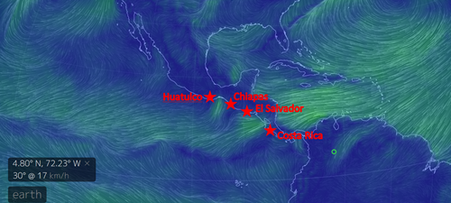
So the next few crossings are going to be tricky. We are now in Huatulco, which is the 2nd to last port in Mexico. The next port is Chiapas - another three day/two night crossing - the first of three such long legs in a row. This crossing to Chiapas can be tricky. We have to cross the dreaded Tehuantepec which can blow up to 50 knots routinely. The map below shows how the winds blow across the low / thin places in Central America from the Atlantic to the Pacific. Today the winds aren't too bad - only 25 knots as shown in this wind map. In Chiapas we will get our exit paperwork to head for El Salvador. Then there is a more typical crossing from Chiapas to El Salvador. Then the third crossing from El Salvador to Costa Rica where we have to cross the Papaguoys - another low spot on the land mass where the winds blow like crazy. The trick of course is to wait for a break in the winds. There is a regular cycle of the winds blowing like crazy for a few days followed by a 2 day break. So these next few crossings will be done when the weather forecast is good - not based on a schedule of any kind!
This wind map was generated from http://earth.nullschool.net/ which is a super cool website that shows the winds anywhere on the globe in real time.

